The Henry Brown Map of Guilford Courthouse
Captain Henry Brown hailed from Bedford, Virginia, where he was a neighbor of Thomas Jefferson. The latter owned Poplar Forest, a plantation where he spent some time, largely involuntarily, during the Revolutionary War. Brown was born in 1760, and lived a long life, dying in 1841 at age 81. The Brown family enjoyed prominence in the region, and Captain Brown bears the credit of starting the family fortune. He was a successful merchant, but indulged other interests, ultimately owning a plantation of several thousand acres. The centerpiece of his plantation was the manor house, Ivy Cliff, usually credited to Captain Brown and believed by most to have been built in the 1790s.
Brown fought in the Virginia militia during the Revolution. He was wounded at the Battle of Guilford Courthouse. There is an application for pension benefits for Henry Brown, from Bedford, born on the correct date (10 August 1760), and wounded at Guilford Courthouse. However, this Henry Brown was drafted into service and remained a private through the end of the war. The similarities are not coincidences, and the application accurately reflects Brown’s service. Brown was not the only citizen who reached wealth and prominence later in life who sustained a boost in his military reputation after the war. So, captain it is.
Brown is of interest in the lore of Guilford Courthouse for more than his participation in the battle. At some point, he was said to have drawn a map of the battlefield. Maps of Guilford Courthouse are precious commodities, and Brown’s feat of creating one put him within the charmed circle of people who tried to put order to the confusion of the battle. The original of the map is in volume 7 of the Brown, Coalter, Tucker Papers in the library of the College of William and Mary.
An archivist noted on the back of the map that it was found in 1926 by H.S. Saunders among old papers at Ivy Cliff. The Saunders family married into the Brown family, and many Saunders lived at Ivy Cliff. Here is the map as it appears today:
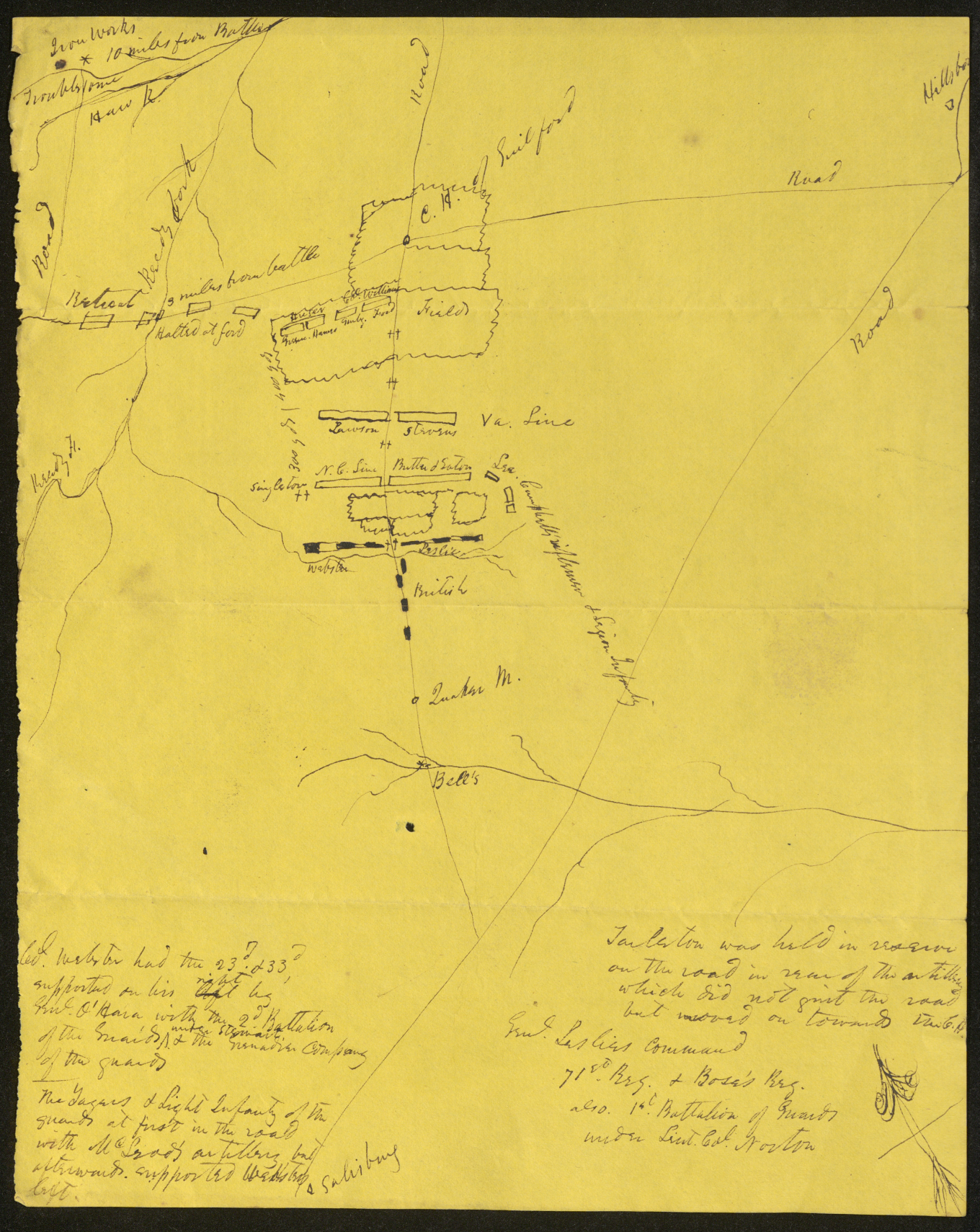
The information written on the map is accurate. On the lower left, the author wrote: “Col. Webster had the 23d and 33d, supported on his right by Gen. O’Hara with the 2d bn. of the Guards under Stewart & the Grenadier Company of the guards. The Yagers & Light Infantry of the guards at first in the road with Macleod’s artillery, but afterwards supported Webster’s left.” On the lower right, he wrote, “Tarleton was held in reserve on the road in rear of the artillery which did not quit the road but moved forward on towards the C.H.” He added, “Gen. Leslie’s Command 71st Reg. & Bose’s Reg. also 1st Battalion of Guards under Lieut. Col. Norton.”
The terrain on the map is also accurate, understanding the map is a sketch. He showed the courthouse at the intersection of the two main roads in the area, with the troops deployed on one side, the Americans’ retreat on the other.
The complete Brown map, including the notes on the back, may be accessed here.
For all these accuracies, there is still plenty of cause for alarm. The map shows a directional arrow in the bottom far right, pointing north, but doing so vastly incorrectly. The most important maps of the battlefield are two British military maps, one attributed to Henry Haldane, an engineer officer on Cornwallis’s staff, the other appearing in Tarleton’s memoirs in 1787. The most notorious defects in the Haldane and Tarleton maps are their directional arrows, pointing 50 degrees away from north, a monumental error that has created much uncertainty as to the reliability of the maps otherwise. Brown’s map shows exactly the same error. If Brown started his map on his own, it would be a remarkable coincidence that he made precisely the same mistake. It is far more likely that he drew the map while relying heavily on Tarleton’s book. After all, as a private soldier in the Virginia militia on the second line of battle, he could not have seen Tarleton or Macleod on the first line, and had no way to know the things he wrote on the bottom of the map. Brown’s map also shows matters not in Tarleton’s book, the cities of Salisbury and Hillsborough, for example, so it appears the author added some matters from memory.
For comparison, the Haldane map may be accessed here.
As readers of this site well know, I have placed great reliance on the fact that no contemporary map of the battlefield records the presence of Hunting Creek, and the Brown map is no exception. Once more, I make the point that if soldiers had to cross deep, steep ravines and wade through water to fight the enemy, they would have mentioned it.
So, the bottom line question: is it real? Well, like almost everything else in life, it depends. If I were authenticating the map for the Smithsonian collection, the answer would be “not on a bet.” It is only an assumption that Henry Brown drew the map. After all, he was the only person living in Ivy Cliff who had fought at Guilford Courthouse. There are no writings where Captain Brown claimed authorship of a battlefield map. In all fairness, any family member who listened to Captain Brown’s stories could have opened Tarleton’s book and drawn the map.
But, just between you and me: it’s real. Brown was a real, historical character whose service at Guilford Courthouse was documented. The map was found in family papers at his residence. The text and terrain are all accurate. The only notable error is one shared by the other military maps, and shows that Brown relied on others for much of what he wrote and drew. When did he put pen to paper? There is no way to know. I tend to the view that he did so late in life, reliving the most important event in his youth, with Tarleton’s book open while he reminisced over the battle. The Brown map seems largely derivative of Tarleton and, therefore, is not an important, original source. But it does reflect the recollections of a veteran of the battle, and as such deserves our esteem.