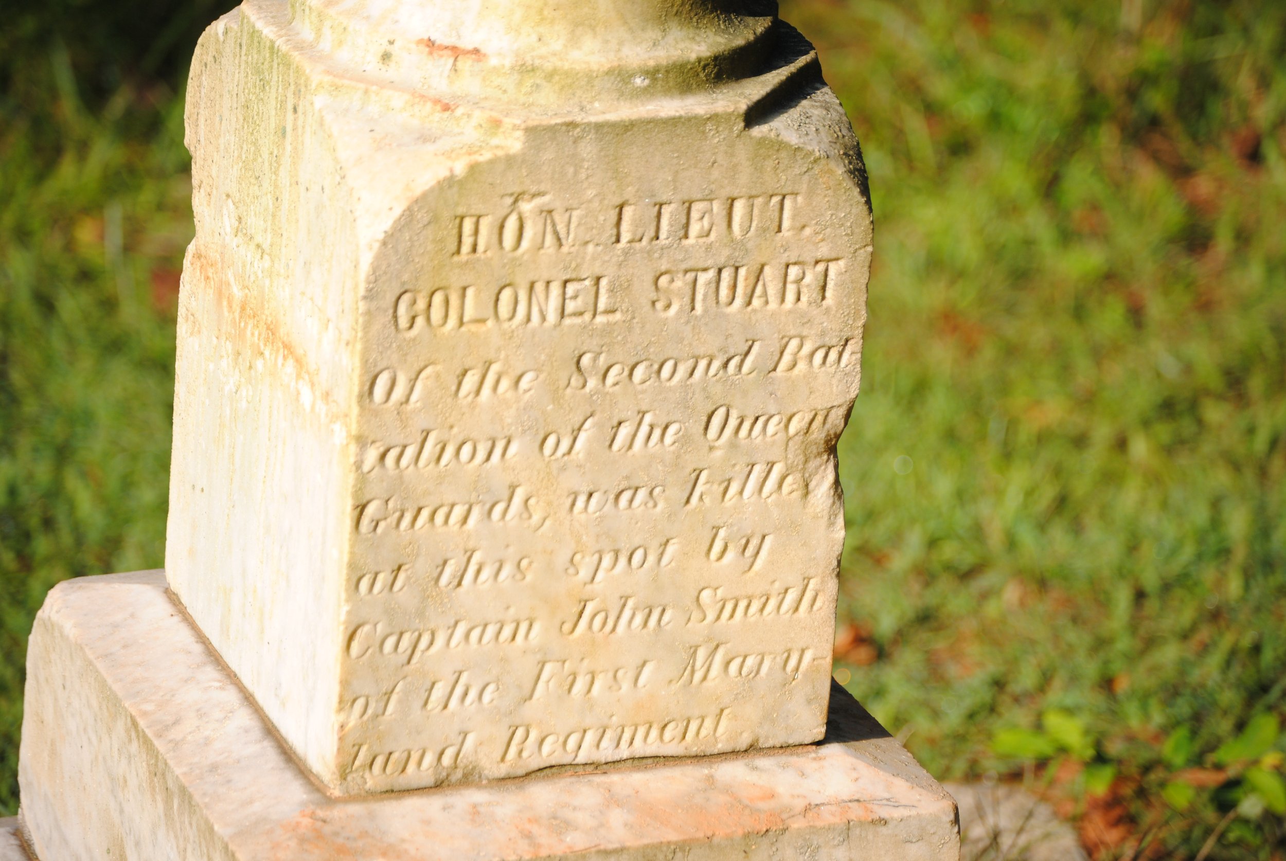
Thomas W. Taylor’s Paper on the Third Line
This page is the fourth in the series dealing with the second battlefield reconstruction at Guilford Courthouse. It begins with “Hunting Creek,” and proceeds with “Brandon” and “Durham.” All three of the earlier pages discuss many of the errors and misconceptions that permeate the second reconstruction.
Thomas W. Taylor kicked off the move to revise the battlefield reconstruction in 1983, when he wrote “The Landmarks of the Battle of Guilford Courthouse” for a graduate history course in 1983. Taylor wrote in a time before archaeology had confirmed the locations of the first and second American lines, denied the authenticity of the Hoskins House, and failed to find the courthouse. Taylor wrote on all these, and, of course, on the location of the third American line.
Taylor’s text may be accessed here:
It was Taylor’s discussion of the third line that triggered the cascade of events leading to the second battlefield reconstruction. This fact was unfortunate, in that Taylor’s argument for moving the third line of battle was tenuous and riddled with mistakes.
Taylor, like Durham, argued for the rigid, bedrock reliability of the distances in the Tarleton map. Taylor also addressed the Haldane map, which he referred to as the “Clinton map,” but noted they were essentially identical. Taylor relied extensively on the point that Tarleton’s map showed 150 yards from the American third line to the courthouse. This, of course, was the same dimension Durham asserted was 176 yards. Either way, Taylor, like Durham, felt the Schenck reconstruction placed the third line too far away. Taylor’s solution, like Durham’s, was to move the third line across the creek, much closer to the courthouse.
The problems with the methodology in Taylor’s paper were legion. Space limitations prevent addressing all of them. One huge problem was Taylor’s contention of the map’s accuracy. Taylor took the time and trouble to measure distances on the ground and compare them to the distances on Tarleton’s map. The results established, conclusively, that Tarleton’s distances were at best estimates, certainly not to be taken too seriously.
Appendix A to Taylor’s text may be accessed here:
He prepared a table of his conclusions, appearing on page 131, in Appendix B to the paper. Space limitations necessitate that one provide the example for all. Taylor compared the distance from Hunting Creek to the intersection of Reedy Fork and Historic New Garden Roads. On the map, this distance was 300 yards. On the ground, he measured 250 yards. Taylor’s point was the map distances were precisely accurate, but the measured distance on the ground was twenty percent larger, betrayingTaylor’s argument for precision.
Taylor’s methodology was deeply flawed. The intersection of Reedy Fork and New Garden Roads was lost years ago, and remains lost to the present. Archaeologists have tried and failed to find it in multiple digs going back to the 1970s. One can only speculate what Taylor thought he was measuring, but whatever it was, it was not the distance to this intersection.
Bizarre as the mistake regarding the intersection was, an even more outrageous mistake arose at the same time. It was so ridiculous that it defies logic even to repeat it, but here it is: Hunting Creek is not on Tarleton’s map. With a completely straight face, he stated that the distance on Tarleton’s map from the intersection to the creek was 250 yards. But the creek appeared nowhere on the map.
Appendix B to Taylor’s text may be accessed here.
The rest of the distances displayed flawed methodology. They are visible on page 131 of Appendix B. There was no pattern. Most ground distances were longer, one shorter, than the map distances. There was no consistent twenty percent differential. The map distances were random, just estimates, and not to be taken too seriously.
Taylor then placed great reliance on the landforms around the third line. He contended the terrain on the eastern bank of Hunting Creek more closely resembled the Tarleton map than the land on the western bank where Schenck placed the third American line of battle.
Taylor was terse and conclusory in his assessment of the terrain: “As the contours of the hillside as portrayed by Tarleton closely match those of the modern topographic map in the area of Hunting Creek, it would appear from Tarleton’s map that the location of the Third Line was along the ridge east of that creek, rather than west of it as presently believed.” Durham, following Taylor, was more specific, asserting the terrain was the key to the mystery, and relying in particular on the map’s depiction of “the twin curved hills” north of the road, which he related to terrain east of the creek.
The map showed nothing of the sort. It actually depicted one large hill immediately north of the road, with a much smaller hill on its northern flank, followed by a still smaller hill. The most notable feature on the map was the fact that the land edged westward as it went north; the third hill sat much farther west than the large one. On the ground, exactly the opposite is true: the land recedes eastward as it moves north.
Appendix C to Taylor’s paper may be accessed here:
More damaging to the Taylor-Durham thesis was Durham’s depiction of the land on which he relied. His argument is best seen on the map on page 20 of his 2004 paper. Durham photocopied a piece of the topographic map, and circled the land to which he referred. His handwritten note said this map showed “the twin hill feature depicted on the Haldane, Tarleton, and Stedman maps.” The hills he circled began 200 yards south of Historic New Garden Road. One constant among all the uncertainty in the original three maps mentioned by Durham was that all three placed the third line north of the road. But, if we accept Taylor and Durham, the third line started 200 yards south of the road, an intolerable error and one that fails for a complete lack of support.
I have attached the Taylor paper in a series of PDFs. The first is the basic text, followed by Appendix A (maps), Appendix B (distances), and Appendix C (illustrations). I have not added Appendix D, which was a photocopy of the Brandon paper, “The Axis of the Battle of Guilford Courthouse,” and finally, the bibliography.
The paper as it exists is not in the best shape. What you see here is what I received from the park rangers. Much of the document has been highlighted. The appendices have the worn appearance of copies made from copies. I first took photos of pages several years ago. At the time, I had a specific project in hand, and photographed only those pages relevant to my project. I went back in 2025, and the paper had suffered greatly; many pages were missing.
I have looked in some obvious places, and this poor version may be all that survives. Taylor died several years ago. If he kept a copy, it went with him. There may well be a copy on file with UNCG, the institution to which he submitted the paper, and if so it would be the last one without additions and deletions.
The pagination is not immediately apparent. Here is what I reconstructed:
Cover page to the paper, not numbered.
Basic text, as numbered, pages 1 through 85.
Appendix A, internal cover page is page 86. Content is pages 87 through 123.
Appendix B, internal cover page is 123 (not a typo; keep reading). Content is pages 124 through 131.
Appendix C, internal cover page is 132. Content is pages 133 through 148.
Appendix D, internal cover page is 149. Content is pages 150 through 173.
Bibliography, internal cover page is 174. Content is pages 175 through 187.
There are a few missing pages. Here is a list:
Basic text: none missing.
Appendix A, maps: missing pages 88 and 89 (multiple views of the “Clinton” map, map no. 1), page 90 (Jessop map, map no. 2), page 93 (Brown map, no. 4), page 95 (map no. 6, Lee), and page 108 (map no. 19, Reid map). All these maps are available from other sources.
Appendix B, distances: missing page 127. I believe this is the only page that has been lost and cannot be recovered from other sources. It looks like it was one more page like 126, a comparison of distances taken from the many texts discussing them.
Appendix C, illustrations: none missing.
Appendix D, Brandon’s “Axis” paper: none missing.
Bibliography: none missing.
Even with all the above, there are questions. The index to the maps is in Appendix B, even though the maps were attached as Appendix A. The index lists 36 maps, of which 25 are starred. Only the starred maps were copied into the appendix. The index and the appendix have different numbering systems, so map number 18 on the index is map number 15 in the appendix.
The last map shared by the index and the appendix was number 33 in the index/25 in the appendix, the “Baer Map.” The index then listed three more maps, none of which were copied into the appendix. The appendix, on the other hand, contained another five maps not appearing in the index: no. 26, the Fred Hughes map; no. 27, park boundaries superimposed on the Tarleton map; 28, an aerial photomap; 29, a map from James MacClamroch, and 30, a then-modern topographical map.
There was a glitch in the pagination. The topographical map, map no. 30, appeared on page 123 of Appendix A. The next page in sequence was the internal cover sheet for Appendix B, followed by the first page of text of Appendix B, numbered 124, making the internal cover sheet a second page 123.